Important Service Change Information

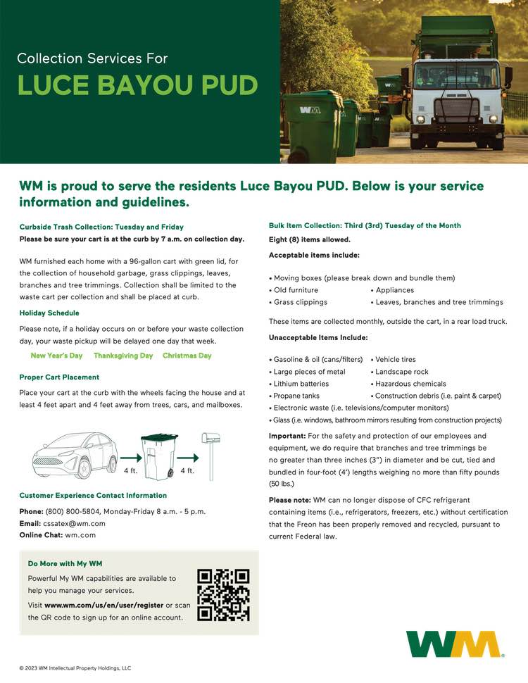
Dear Luce Bayou PUD Resident:

Beginning August 1, 2023, WM is moving to standardized trash cart collection in the Luce Bayou PUD community. Collection with a standardized 96-gallon cart is more efficient and cleaner for your community.

As part of this transition, a green 96-gallon trash cart will be delivered to each residence. The cart will be delivered on your driveway or on the street-side of your home.

With standardized collection, all material must fit inside the cart with the lid closed. No extra bags or material outside the cart will be collected. Items that are oversized and do not fit into your cart will be collected on your bulk collection day.

Waste Collection Days

  • Waste Collection will be every Tuesday and Friday. Your first Tuesday and Friday 96-gallon trash collection will be on Tuesday, August 1 and Friday, August 4.

Bulk Collection Days

  • Bulk collection will be the third Tuesday of each month. Your first August bulk collection will be Tuesday, August 15. Bulk collection is not to exceed eight (8) items.

You may place out eight (8) items for collection. Acceptable items include broken down and bundled moving boxes, old furniture, bagged grass clippings, leaves, branches, and tree trimmings. Branches and tree trimmings should be tied and bundled and no more than three inches (3″) in diameter and four feet (4′) in length and weigh no more than forty to fifty (40- 50) pounds.

Cart Placement

  • Please have your cart at the curb for collection by 7 a.m. each service day.
  • Please place your cart at least three feet from all objects, including your mailbox, car or Place the wheels of the cart toward the house.

Service Holidays

WM observes the following holidays: New Year’s Day, Thanksgiving Day, Christmas Day. Service will be delayed by one day if collection falls on or follows one of these observed holidays.

Please do not hesitate to call us at (800) 800-5804 Monday-Friday 8 a.m. to 5 p.m. or email us at cssatex@wm.com if you have questions regarding your service.

Thank you for entrusting WM to serve your community’s collection and disposal needs. It is an honor to serve your community.

Sincerely, WM of Texas

Hurricane Preparation Checklist

The traditional hurricane season is June 1 through November 30. It is time to make a plan and be ready. Here are a few resources for this year’s Hurricane Preparedness Week:

  • Know your risk – Hurricanes are not just a coastal problem. Impacts from wind and water can be felt many miles inland. Significant impacts can also occur regardless of the storm’s strength.
    • Consider your threats: Storm surges, flooding from heavy rain, strong winds, tornadoes, rip currents
    • Determine if you live in a flood-prone area
    • Find out if you live in an evacuation zone
  • Avoid having to rush through potentially life-saving preparations by getting your disaster supplies now. Supplies may not be available just before a storm arrives. Get an insurance review early, as flood insurance requires a 30-day waiting period.
    • Develop an evacuation plan
    • Assemble disaster supplies: food, water, batteries, charger, radio, cash
    • Get an insurance checkup and document your possessions
    • Create a communication plan with a hand-written list of contacts
    • Strengthen your home
  • Understand forecast information before a storm. This can tell you a lot about what is expected, including the storm’s path, rainfall amounts, wind speeds and more. Most importantly, it lets you and your family know what actions to take to prepare, monitor, shelter or evacuate. Visit www.hurricanes.gov for more information.
    • Rely on forecasts from your local National Weather Service office
    • Know your alerts and the difference between Watch and Warning
    • Focus on potential impacts, regardless of storm size and category
    • Know that deadly hazards occur well outside of the Forecast Cone
  • Know what to do during a storm. Whether you’ve evacuated or are sheltering in place, know what to expect from the hazards you may face. Remain vigilant, stay up-to-date with the latest forecasts and alerts, and continue to listen to local officials.
    • Protect your hone: Cover windows, secure doors and loose items
    • Determine sheltering options and consider your pets
    • Ready you go-bag, meds and supplies, charge phones, fill up/charge vehicle
    • Help your neighbors, especially the elderly and other vulnerable people
    • Follow evacuation orders if given
  • A key part of hurricane preparedness is understanding the dangers that remain well after a storm. This is not the time to put your guard down. Nearly half of hurricane fatalities occur after the storm.
    • Use caution after storms: If evacuated, only return home when directed it is safe to do so
    • Remain vigilant, as hazards remain: Heat, downed powerlines, floodwaters, etc.
    • Clean up safely: Don’t push yourself and check on neighbors
    • Only use generators outdoors, 20+ feet from your house
    • Prepare for the likelihood that help and communications may not be available
  • Do not wait to take action! Start preparing today!
    • Determine your risks from water and wind
    • Begin preparing now, before a storm
    • Learn how to understand hurricane forecasts and alerts
    • Learn what to do before, during and after a storm

Freeze Warnings and Hard Freeze Warnings Expected

The National Weather Service has advised that subfreezing temperatures are likely beginning Thursday night and into Friday morning following the passage of a strong cold front. Freeze Warnings and possible Hard Freeze Warnings can be expected. High temperatures could quite possibly remain below freezing throughout the day on Friday and not warm up above freezing until during the day on Saturday.

Steps for Winterizing your Home

  • Insulate pipes with insulation sleeves, wrapping or using slip-on foam pipe insulation. Do not leave any gaps without insulation as cold air can affect the pipe in these spaces.
  • Winterize your sprinkler system by turning the water off to your irrigation system and drain your backflow preventer.
  • Maintain a heating source inside the building to protect pipes against cold.
  • Open cabinets underneath faucets.
  • Exterior hose bibs are normally left unattended, disconnect hoses and insulate faucets with covers or blankets.
  • House Shut off valve: Know where your shut off valve is located in case of an emergency. Valve is usually on the side of the house near the garage. Some homes the valve is inside the garage wall.
  • If you choose to leave a faucet dripping, please only let the faucet drip slowly. NO STEADY STREAMS.
  • If traveling for the Holidays, it is recommended that you turn the water off at the street and drain all your plumbing.

Weather Update as of 12/19/22

  • The approaching arctic air outbreak will be the coldest air mass since February 2021.
  • It is forecast that temperatures will drop quickly Thursday Night into Friday Morning.
    • Temperatures likely to be in the teens north of Highway 105, near 20 degrees near I-10, and in the mid 20s south of I-10
    • Many areas could be below freezing for 20-36 hours
  • Many areas will likely not get above freezing on Friday.
  • Though warming into the upper 30s will occur on Saturday, temperatures will drop below freezing on Saturday Night/Sunday Morning

Important to Protect the Four Ps

  • People
  • Pets
  • Plants
  • Pipes

National Weather Service Information

  • Thursday into the Christmas Holiday
    • The Arctic front is on track to move into the area on Thursday. It will bring periods of freezing temperatures (and likely some <25°) into much of the weekend.
    • Too early to confidently pinpoint exactly just how low readings will fall, or how many consecutive hours below freezing any single location will get.
    • Confidence is high that we will see some bitterly cold air and freezing temperatures, but don’t focus on any individual model, or model run, this far out.
    • The specifics will change as time progresses.
  • All businesses and residents should begin preparation for some hard freezes before the coldest weather is set to move in on Thursday.
  • For industry that needs an extended amount of lead time, the NWS encourages individuals to review plans/actions that might need to be implemented should conditions warrant (any extended durations of subfreezing temperatures, gale force winds, high seas, low water conditions, etc.)

Notice Regarding Extreme Weather Emergencies

This communication is to notify you that Luce Bayou Public Utility District, your retail water and sanitary sewer provider, is:

  • prohibited from imposing late fees or disconnecting retail water or sewer service for nonpayment of bills that are due during an extreme weather emergency until after the emergency is over;
  • required to offer a payment schedule to a customer who requests such a schedule for unpaid bills due during an extreme weather emergency; and
  • prohibited from disconnecting retail water or sewer service for nonpayment of bills due during an extreme weather emergency until after a payment schedule has been offered and the customer has either declined to accept the payment schedule in a timely fashion or violated the terms of the payment schedule.

For purposes of this communication, an “extreme weather emergency” is defined as a period beginning when the previous day’s highest temperature in an area did not exceed 28 degrees Fahrenheit and the temperature is predicted to remain at or below that level for the next 24 hours according to the nearest National Weather Service reports for that area. An extreme weather emergency is over on the second business day the temperature exceeds 28 degrees Fahrenheit.

Aviso Sobre Emergencias Climáticas Extremas

Esta comunicación es para notificarle que su proveedor de agua y alcantarillado sanitario Luce Bayou Public Utility District es:

  • prohibido imponer cargos por demora o desconectar el servicio de agua o alcantarillado por falta de pago de las facturas que vencen durante una emergencia climática extrema hasta después de que termine la emergencia;
  • obligado a ofrecer un plan de pago a un cliente que solicite dicho acuerdo para las facturas adeudadas durante una emergencia climática extrema; y
  • prohibido desconectar el servicio de agua o alcantarillado por falta de pago de facturas adeudadas durante una emergencia climática extrema hasta que se haya ofrecido un plan de pago y el cliente se haya negado a aceptar el plan de pago de manera oportuna o haya violado los términos del plan de pago.

A los fines de este comunicado, una “emergencia climática extrema” se define como un período que comienza cuando la temperatura más alta del día anterior en un área no superó los 28 grados Fahrenheit y se pronostica que la temperatura permanecerá en ese nivel o por debajo de este durante las próximas 24 horas. de acuerdo con los informes del Servicio Meteorológico Nacional más cercano para esa área. Una emergencia climática extrema termina el segundo día hábil en que la temperatura supera los 28 grados Fahrenheit.